
 Enesgy
The vast majority of commercial and consumer goods, construction materials, fuel, and food for the entire state of Alaska first arrive at the Port of Alaska. The Port is an enterprise department of the Municipality of Anchorage, and it faces many challenges common to other ports as well as unique to “America’s Last Frontier”. Extreme climate, seismic instability, and tidal ranges, a combination rarely seen in any other commercial port, place unique operational challenges and accelerate wear and tear on the Port’s facilities. Meanwhile, the Port, which operates as a landlord like most US ports, is tasked with maximizing the benefits from the land entrusted to it by the people of Alaska. These factors place extreme pressures on the Port to maximize efficient and profitable use of its leasable lands, comply with agreements with its tenants and shippers, and maintain the supply chain movement at all times while meeting its public obligations of transparency, accountability, security, and economic growth for the people of the state.
In 2016, observing the advances in the use of GIS in larger ports like Los Angeles, Oakland, San Diego, and Rotterdam, the Port of Alaska embarked on a program to start up its own GIS program. This was initiated as part of a plan to establish an asset management program at the Port, as well as anticipating a decade-long modernization of its facilities. Initial acquisition of Esri ArcGIS® GIS software and data, and the establishment of a VertiGIS Geocortex®-based map viewer, proved very timely when, in 2018, a 7.1 earthquake struck just 8 miles from the Port. GIS was used to rapidly survey and document the damage and accelerate the Port’s applications for federal disaster relief.
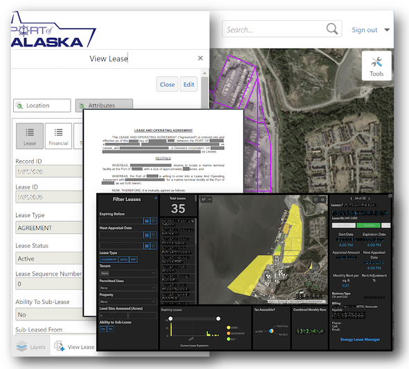
In 2019, the Port began deploying Enesgy® Lease Manager, the affordable GIS-based software from NSGIS® designed specifically for the management of commercial leases. Enesgy provides powerful integration between ArcGIS, which stores all present and past lease boundaries and dozens of fields describing each lease in a database, and the Port’s Microsoft® SharePoint® document repository, which now stores all the lease agreements, certificates of insurance, and other lease-related documents. This migration from on-premises Excel® and file-server storage of documents to a web-based cloud solution also proved timely as port personnel transitioned to working from home during the COVID-19 pandemic. As staff return to the office, the robust Enesgy software automatically notifies them of upcoming events like lease renewals and insurance certificate expirations, generates lease abstract reports, and provides intuitive portfolio visualizations in a management dashboard.
Complimenting NSGIS for the deployment of Enesgy at the Port, the Director of the Port of Alaska’s Modernization Program, Sharen Walsh P.E., recently commented, “You delivered exactly what you said you would, all those years ago when we first started on this journey!”
NSGIS is proud to contribute to both the success and resilience of the Port of Alaska and other ports with GIS-based property and asset management solutions.