
 Enesgy
[threecol_two]
NSGIS delivers award winning Port Solution for Port of Los Angeles
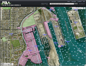 The Port of Los Angeles (POLA) is
 ![]() one of the busiest ports in the United States. Like most ports it is a multi-faceted enterprise, concerned with not only port operations but also property and lease management, wharf/dock management, utility maintenance and security. POLA container yards and warehouse facilities handle over $250 billion dollars in cargo each year.
one of the busiest ports in the United States. Like most ports it is a multi-faceted enterprise, concerned with not only port operations but also property and lease management, wharf/dock management, utility maintenance and security. POLA container yards and warehouse facilities handle over $250 billion dollars in cargo each year.
The Challenges
The Port of Los Angeles is a highly dynamic environment, with frequent and significant real-time physical changes.
[unordered_list style=”green-dot”]
- Disparate and duplicated data, multiple versions of the built and natural environments, including:
– Land and water boundary – large scale land reclamation
– Weather and water conditions
– Roads, railroads and container terminals – layout and operations - Threats to the security and safety of port operations
- Operational system diversity
- Demand for increased efficiencies
- Need for a common view of information
[/unordered_list]
The NSGIS Solution
NSGIS implemented an Esri-based Enterprise GIS that cuts across operational, security and emergency management issues.
[unordered_list style=”green-dot”]
- Data and ready-made maps served directly from Esri ArcGIS for Server to other software and systems, e.g., Situational Management, Lease Management, and Environmental database systems.
- Integrated display of static GIS data and dynamic data including vessels, traffic, weather and Blue Force Tracking for Port Police.
- Delivery and integration of all geospatial information via geoPOLA – the Port-wide Intranet GIS web map viewer.
[/unordered_list]
In addition to the accolades that The Port of Angeles received for this project, the Port of Los Angeles staff, Esri and NorthSouth GIS collaborated on creating a video that describes how much the Enterprise GIS system truly revolutionized the day to day operations at the Port:
Port of Los Angeles Chief of Police: Ronald J. Boyd
Port of Los Angeles Director of Operations: John Holmes
Port of Los Angeles Enterprise GIS Manager: Christine Thome
Opportunity
NorthSouth GIS is now offering the delivery of similar capabilities as implemented at the Port of Los Angeles for both on-site implementation or via our cost effective, secure cloud technology deployment.
The Port of Los Angeles Case Study (PDF)
Interested?
Call us at (800) 866-5013 ext 11 or email us at ports@nsgis.com today!
[/threecol_two][threecol_one_last]
[content_block id=5789]
[content_block id=5451]
[/threecol_one_last]