 Enesgy
ArcUser —
By Matthew DeMeritt, Esri Writer
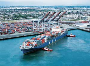
The Port of Los Angeles’ enterprise GIS system provides operational awareness and integrates both static and dynamic data at one of the world’s busiest ports.
In terms of shipping container volume and cargo value, the Port of Los Angeles is the leading seaport in North America according to the American Association of Port Authorities (AAPA). It encompasses 7,500 acres with 43 miles of waterfront and 27 cargo terminals.
Ports have larger and more complicated infrastructures than most gateways of commerce. The physical structure can change over time as roads and railroads move, new docks are built, and infilling with rocks and gravel creates additional shoreline.
In 2009, the port hired Esri and GIS consultant NorthSouth GIS LLC to create a system that would aggregate, serve, and share port data throughout all its divisions…